
Jagdrevier Plus
Im Play Store erhältlichDein digitales Jagdrevier — Karte, Tagebuch, Abschussplan,
Wetter und Kontakte immer dabei.
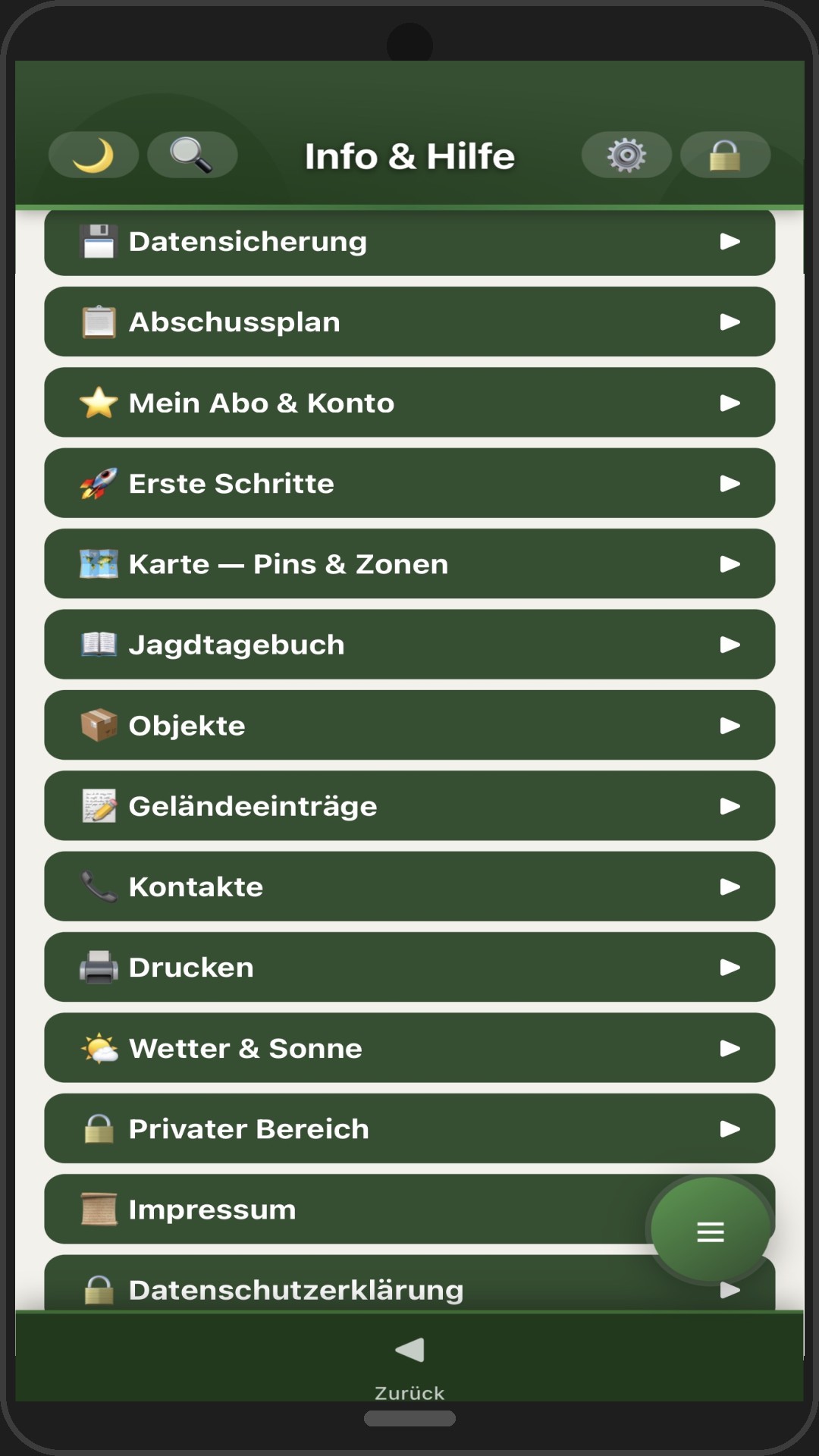
Jagdrevier Plus vereint alle wichtigen Werkzeuge in einer App — intuitiv, schnell und auch offline verfügbar.
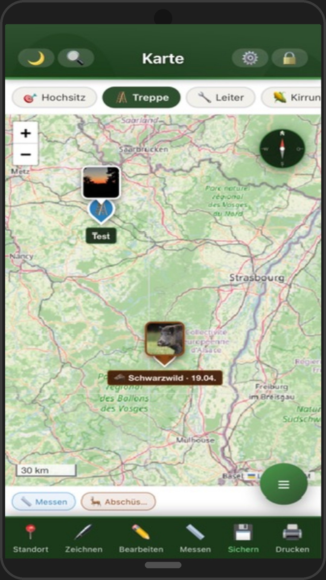
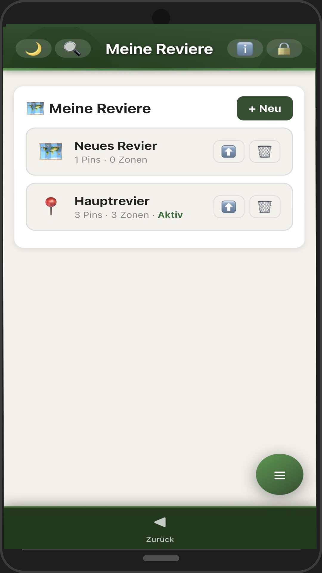
Pins für Hochsitze, Kirrungen und Wasserstellen. Zonen zeichnen mit Flächenberechnung. GPS in Echtzeit. Offline-Kacheln für Gebiete ohne Empfang.
Stände mit Nummern und Teilnehmer-Namen auf der Karte setzen. Alle anderen Pins werden automatisch ausgeblendet. Karte teilen oder drucken — nur die Drückjagd-Stände mit Namen werden angezeigt. Ideal zur Vorbereitung am PC und Verteilung an alle Teilnehmer.
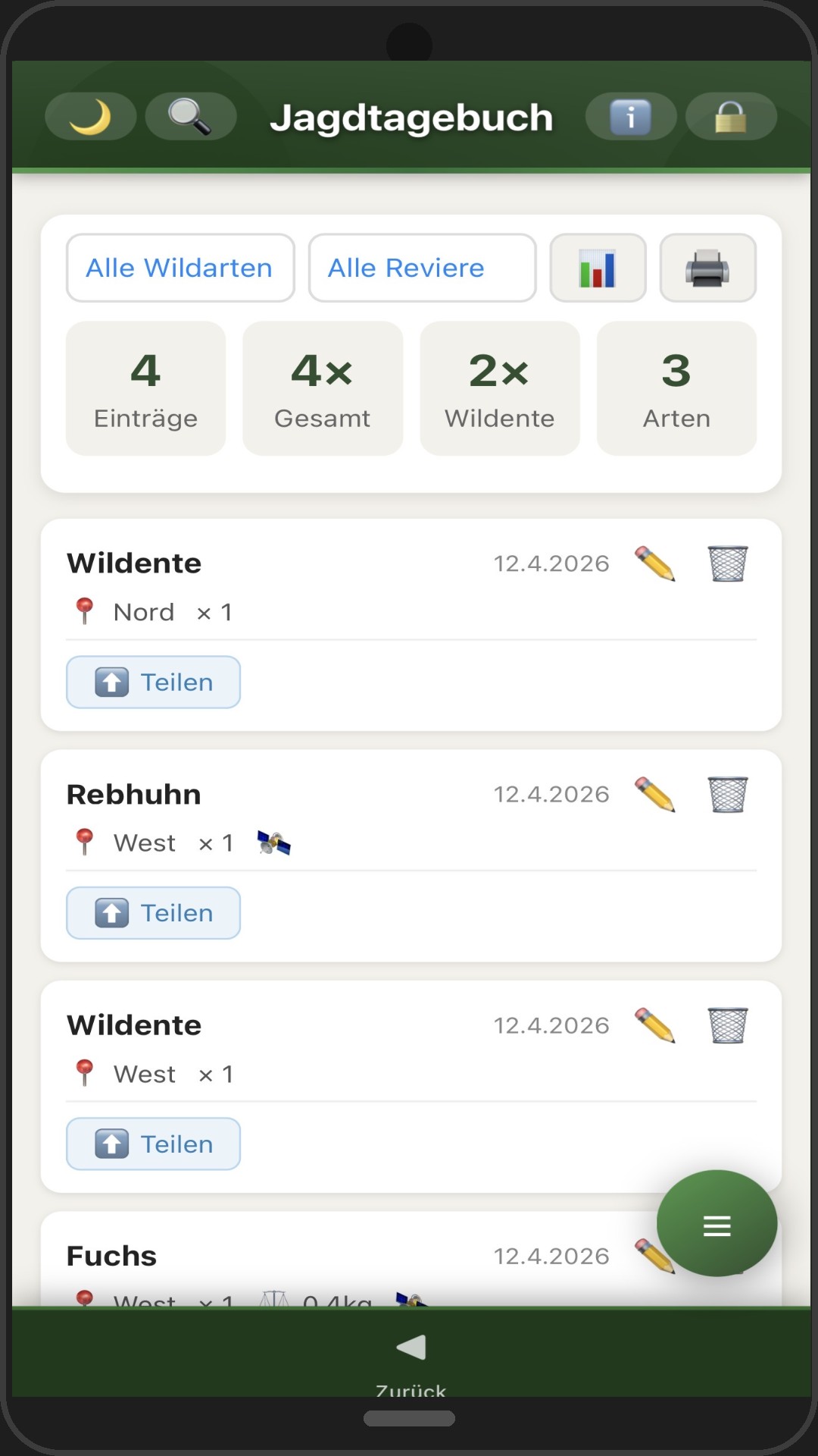
Jeden Abschuss vollständig erfassen — 19 Wildarten, GPS-Position, Fotos . Filter nach Jahr, Revier und Wildart. Statistik und Druckfunktion.
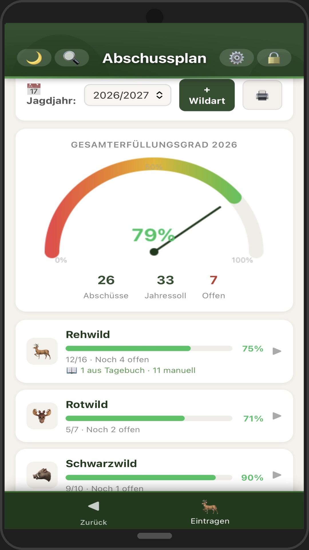
Jahresplan mit Fortschrittsbalken pro Wildart und Klasse. Automatische Synchronisation mit dem Jagdtagebuch. Dashboard-Übersicht auf einen Blick.
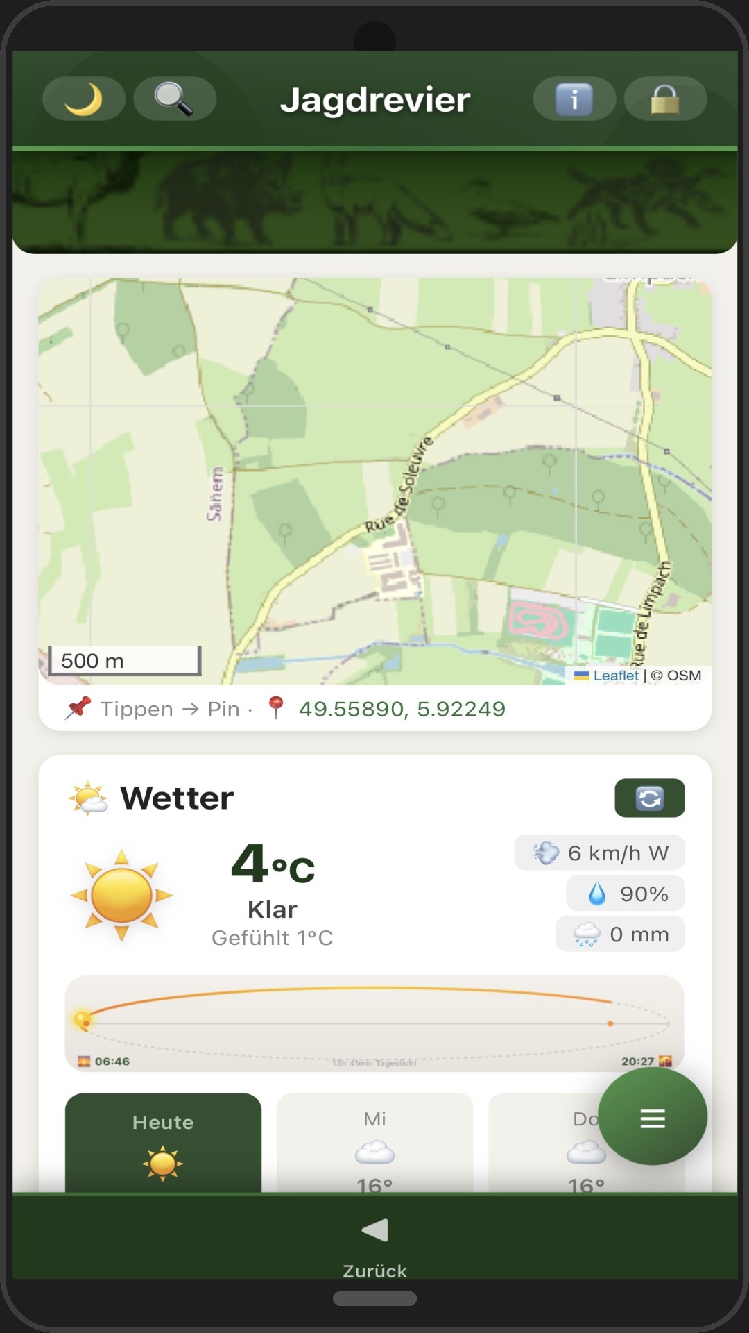
Aktuelles Wetter per GPS. Luftdruck mit Trend-Pfeil, Mondphase und Sonnenaufgang — alle relevanten Infos für die Jagdplanung.
PIN-geschützter Bereich für vertrauliche Dokumente, Fotos und Notizen. Vollständig lokal gespeichert — kein Cloud-Zugriff möglich.
Vollständiges Backup aller Daten inkl. Fotos und Kontakte. Auto-Backup Erinnerung. Einfacher Geräteübertrag per Backup-Datei.
Wische durch die Screenshots und entdecke alle Funktionen.
Echte freigeschaltete Rückmeldungen von Nutzern.
- Interaktive Revierkarte mit GPS
- Jagdtagebuch mit Fotos
- Abschussplan mit Statistiken
- Jagdwetter, Mondphase & Luftdruck
- Privater Bereich mit PIN-Schutz
- Automatisches Backup
- Alle zukünftigen Updates inklusive
- Alle Daten bleiben auf deinem Gerät
Was ist Jagdrevier Plus?
Jagdrevier Plus ist eine digitale Jagdverwaltungs-App (PWA) mit interaktiver Revierkarte mit GPS, Jagdtagebuch mit Fotos, Abschussplan mit Statistiken, Jagdwetter mit Mondphase und einem PIN-geschützten privaten Bereich – auch offline nutzbar.
Was kostet Jagdrevier Plus?
Das Premium-Abo kostet 11 € pro Jahr und enthält alle Funktionen sowie alle zukünftigen Updates.
Auf welchen Geräten funktioniert die App?
Jagdrevier Plus läuft auf iOS, Android und im Browser. Die App ist auch im Google Play Store verfügbar und funktioniert offline.
Wo werden meine Jagddaten gespeichert?
Alle Revier- und Tagebuchdaten bleiben lokal auf deinem Gerät. Ein automatisches Backup schützt deine Daten zusätzlich.
In welchen Sprachen ist die App verfügbar?
Jagdrevier Plus ist dreisprachig: Deutsch, Französisch und Englisch – ideal für Jäger in Luxemburg, Deutschland, Frankreich und Belgien.
Der ballistische Rechner für Vorhalt, Wind, Wetter und eigene Munition — ideal als Ergänzung zu Jagdrevier Plus.
Jagdrevier Plus
Ouvrir on Play StoreVotre territoire de chasse numérique — carte, journal, plan de tir,
météo et contacts toujours à portée de main.
idz.lu/jagdplus
Jagdrevier Plus regroupe tous les outils essentiels en une seule application — intuitive, rapide et disponible hors ligne.
Repères pour miradors, agrainage et points d'eau. Dessin de zones avec calcul de surface. GPS en temps réel. Tuiles hors ligne pour les zones sans réseau.
Placez des postes numérotés avec le nom des participants sur la carte. Tous les autres repères sont masqués automatiquement. Partagez ou imprimez la carte — seuls les postes de battue avec les noms apparaissent. Idéal pour la préparation sur PC et la distribution à tous les participants.
Enregistrement complet de chaque tableau — 19 espèces, position GPS, photos . Filtres par année, territoire et espèce. Statistiques et impression.
Plan annuel avec barre de progression par espèce et classe. Synchronisation automatique avec le journal de chasse. Tableau de bord en un coup d'œil.
Météo actuelle par GPS. Pression atmosphérique avec flèche de tendance, phase lunaire et lever du soleil — toutes les infos clés pour planifier votre chasse.
Espace protégé par code PIN pour documents confidentiels, photos et notes. Stockage exclusivement local — aucun accès cloud possible.
Sauvegarde complète de toutes les données, y compris photos et contacts. Rappel de sauvegarde automatique. Transfert facile vers un nouvel appareil.
Faites défiler les captures d'écran et découvrez toutes les fonctionnalités.
Retours validés de vrais utilisateurs.
- Carte interactive du territoire avec GPS
- Journal de chasse avec photos & vidéos
- Plan de tir avec statistiques
- Météo, phase lunaire & pression atmosphérique
- Espace privé protégé par code PIN
- Sauvegarde automatique
- Toutes les mises à jour futures incluses
- Toutes les données restent sur votre appareil
Qu'est-ce que Jagdrevier Plus ?
Jagdrevier Plus est une application de gestion de territoire de chasse (PWA) avec carte interactive GPS, journal de chasse avec photos, plan de tir avec statistiques, météo de chasse avec phase lunaire et un espace privé protégé par PIN – utilisable hors ligne.
Combien coûte Jagdrevier Plus ?
L'abonnement Premium coûte 11 € par an et inclut toutes les fonctionnalités ainsi que toutes les mises à jour futures.
Sur quels appareils l'application fonctionne-t-elle ?
Jagdrevier Plus fonctionne sur iOS, Android et dans le navigateur. L'application est aussi disponible sur le Google Play Store et fonctionne hors ligne.
Où sont stockées mes données de chasse ?
Toutes les données de territoire et de journal restent stockées localement sur votre appareil. Une sauvegarde automatique protège vos données.
Dans quelles langues l'application est-elle disponible ?
Jagdrevier Plus est trilingue : allemand, français et anglais – idéal pour les chasseurs au Luxembourg, en France, en Belgique et en Allemagne.
Le calculateur balistique pour l’avance, le vent, la météo et vos munitions — idéal avec Jagdrevier Plus.
Jagdrevier Plus
Open in Play StoreYour digital hunting territory — map, journal, shooting plan,
weather and contacts always at your fingertips.
idz.lu/jagdplus
Jagdrevier Plus combines all essential tools in one app — intuitive, fast and available offline.
Pins for tree stands, bait stations and water points. Draw zones with area calculation. Real-time GPS. Offline tiles for areas without signal.
Place numbered stands with participant names on the map. All other pins are hidden automatically. Share or print the map — only the driven hunt stands with names are shown. Perfect for preparation on PC and distribution to all participants.
Record every harvest in full — 19 wildlife species, GPS location, photos . Filter by year, territory and species. Statistics and print function.
Annual plan with progress bars per species and class. Automatic sync with the hunting journal. Dashboard overview at a glance.
Current weather by GPS. Air pressure with trend arrow, moon phase and sunrise — all key information for planning your hunt.
PIN-protected area for confidential documents, photos and notes. Stored exclusively locally — no cloud access possible.
Full backup of all data including photos and contacts. Auto-backup reminder. Easy device transfer via backup file.
Swipe through the screenshots and discover all the features.
Approved feedback from real users.
- Interactive territory map with GPS
- Hunting journal with photos & videos
- Shooting plan with statistics
- Hunting weather, moon phase & air pressure
- Private section with PIN protection
- Automatic backup
- All future updates included
- All data stays on your device
What is Jagdrevier Plus?
Jagdrevier Plus is a digital hunting territory management app (PWA) with an interactive GPS map, hunting journal with photos, shooting plan with statistics, hunting weather with moon phase and a PIN-protected private area – works offline too.
How much does Jagdrevier Plus cost?
The Premium subscription costs €11 per year and includes all features plus all future updates.
Which devices does the app work on?
Jagdrevier Plus runs on iOS, Android and in the browser. The app is also available on the Google Play Store and works offline.
Where is my hunting data stored?
All territory and journal data stays locally on your device. An automatic backup additionally protects your data.
Which languages is the app available in?
Jagdrevier Plus is trilingual: German, French and English – ideal for hunters in Luxembourg, Germany, France and Belgium.
The ballistic calculator for lead, wind, weather and custom ammunition — perfect alongside Jagdrevier Plus.